Project
UNECA SchoolMap
cat ~/projects/uneca_schoolmap.md
Last updated:
UNECA SchoolMap
SchoolMap is a platform built for UNECA to map schools across Cameroon, monitor incidents that affect the education system, and give decision-makers a geographic view of where schools and incidents are concentrated. The project ships as three coordinated surfaces: a web administration console, a mobile application for the public and focal points, and a lightweight data-collection app for surveyors in the field.
I was the lead developer on this project and was responsible for the design, development, and deployment of all three applications against a shared backend.
- Project Status: Stable
- Product Page: SchoolMap
Web administration console
The web app is the control centre for the programme.
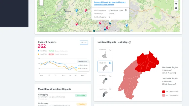
- Dashboard — total incident reports, total schools and total users broken down by North-West and South-West regions, with an incident trend chart, an incident heat map and a school-concentration map.
- School database — map view, heat-map view, table view and full-screen map. Map layers include Standard, Satellite, Terrain and Incident Heat Map. Schools can be added manually or imported from a file, with rich media attached.
- Incident reports — submit an incident, browse the table, switch between quick view and detailed view, moderate via approve/close actions, review media, and follow the comment thread.
- User management — full directory, role and permission matrix, signup request queue and invite-new-user flow with confirmation.
- Focal points — designate a school-level focal point responsible for on-the-ground reporting.
- Notifications, archives, settings and a guided registration flow (personal info, work info, password strength and confirmation).
Field mobile app
The mobile app gives focal points, administrators and members of the public a phone-friendly way to participate.
- Onboarding, login, registration and password recovery.
- Dashboard — live map with incident pins and a “Most Recent Incidents” stream.
- Schools list and details — filter by region and division, browse a school’s profile, interactions and archived state.
- Incident reports — list with filters, detail view with media, casualty breakdown, comments and moderator actions.
- Heat maps — interactive heat maps scoped to the North-West, South-West and individual divisions.
- Submit incident report — select school, category, casualties, upload media and agree to the submission policy.
- Map bubbles and map layers — tap a point on the map to open a slide-in card; switch between standard and heat-map layers.
- Guest mode — browse schools and incident reports without an account.
- Focal-point management, notifications, and bulk school import.
Field data-collection app
A focused Android utility for surveyors collecting school data in the field.
- Add a school with situation, operation and contact information, including level, type, ownership and days of operation.
- Sticky media capture — attach photos and short videos to each school during the survey.
- Offline-first storage with sync when connectivity returns, and optional trial mode that routes data to a test destination.
- Bilingual interface (English / French) and GPS-based coordinates.
Technologies
- Mobile: Flutter, Android
- Web: TypeScript, modern web stack
- Mapping: Web and mobile map renderers, custom heat-map layers
- Backend: shared API, media storage, Google Sheets export (data-collection mode)


